Tensar+ Geotechnical Design Software


Tensar+ Geotechnical Design Software

Tensar+ is a free, cloud-based geotechnical design software that allows engineers, contractors, and owners to design with geogrid in a variety of applications. The newly enhanced design software features a simplified user experience with all the features engineers have come to expect and depend upon with Tensar software.

Use the platform to design your project, customise its specifications and see the cost-savings in real time.

The Tensar+ geotechnical design software platform enables you to:

  • Design and evaluate project specs
  • Compare alternative materials and project conditions
  • See the cost and time savings in real time as you change parameters
  • Analyse the sustainability of your projects.
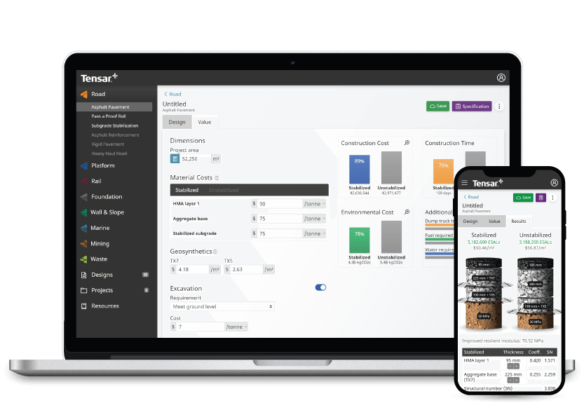

A mock-up of Tensar+ software on a mobile and laptop screen

Choose from a number of construction and geotechnical design software modules

Tensar+ has a number of modules available to help support your construction and geotechnical design projects. Discover our current and upcoming design modules below.

Stacked Image 0

Road construction software

With our road design and construction software module, design engineers can visualise, prepare and understand the parameters and requirements of projects prior to construction, including the specifications for stabilised layers. By mechanically stabilising the unbound layers of a road pavement design, you can maximise the cost and carbon emission savings that can be attained through reduction of the pavement thickness in construction. Tensar’s approach utilises the most up to date knowledge of how a geogrid works when included in a roadway subject to dynamic traffic load.

Temporary works software

Temporary working platforms are an incredibly important aspect of many construction projects, providing construction workers and engineers with stable and safe working areas. By using Tensar+ temporary works design module, you can utilise Tensar’s most recent application technology for mechanically stabilised working platforms and provide safe platforms saving project cost and increasing environmental credentials. Tensar’s “T-Value” design approach is a credible alternative to the guidance offered in BR470 with a proven track record and is implemented into Tensar+ software.

Subgrade stabilisation software

Working on weak or variable ground usually presents considerable construction challenges, therefore designing a secure mechanically stabilised layer prior to construction is essential. By using the Tensar+ subgrade stabilisation module, mechanically stabilised layers can be designed prior to construction, further protecting the subgrade and improving bearing capacity. Tensar’s subgrade stabilisation design methods and solutions are widely accepted and utilised worldwide.

More modules coming soon

We have a number of design modules that are yet to be released, and these will be greyed out on the platform. Some of our upcoming modules include:

  • Mechanistic-Emperical Pavement Design
  • Rigid Pavement Design
  • Walls and Slopes Design


To stay up to date on their release status, sign up for free with Tensar+ today, click on your chosen module heading and select the notification button to receive an email notifying you of each module release.

Stacked Image 0


What is geotechnical design software?

Geotechnical design software is a specialist program that enables design engineers to virtually build the geotechnical elements of a site. This software allows design engineers to easily carry out solutions within unpaved road design, working platforms, foundation stabilisation and more.

Tensar+ is a geotechnical software designed to work specifically with Tensar geogrids, a offering market-leading solutions for road, rail, and trafficked areas. As the industry leader for geogrids used in stabilisation and reinforcement applications, using our construction software alongside our products will ensure you can generate performance based solutions with quantified Tensar value.

Geotechnical design software on desktop, mobile, and tablet

Our geotechnical software is completely cloud-based and free to use on the go – access Tensar+ anywhere, anytime, and any place. You don't need extra hard drive space on your device, or any special requirements to get your designs started. And if your team needs to design out in the field, simply download the app.  


Report, research, and collaborate

With Tensar+ geotechnical design software, your project will be fully supported by our expert knowledge and years of extensive research. The resources section of our construction software contains many professional assets including product information, background on applications, and design methods and training. If you ever encounter any issues with using Tensar+, we have a large number of frequently asked questions to help you complete your project – and we also offer bespoke design support.

Reporting and collaborating on geotechnical projects has never been easier with our construction software. Not only can notes be added to the design for quick reference points when designing, reports can be exported and shared online, via email, or in print format.

How to get started with Tensar+ geotechnical design software

Getting started with Tensar+ is quick, easy, and free. Simply visit the Tensar+ website and sign up for an account, then start a new design or project directly from the homepage.

Frequently Asked Questions

Do all geogrids of the same strength work the same?

No. Geogrid strength does not correlate to in-ground performance, which has been demonstrated in multiple studies (Watts et al., 2004 & Giroud & Han, 2006). The ability of the geogrid to interlock and confine the aggregate subjected to traffic loading is fundamental to deliver enhanced performance of the mechanically stabilized layer (MSL). This enhanced performance can only be measured through full-scale in-ground trafficking testing. Geogrid characteristics such as rib shape, aperture shape, polymer type and material structure configuration, rib thickness, in-plane stiffness, junction shape, geogrid-aggregate compatibility and many other factors are contributors to the amount of interlock and confinement achieved, and therefore, enhanced performance of the MSL.

What is the difference between Tensar+ and TensarPave?

TensarPave is Tensar legacy software that was downloaded directly onto a user’s PC and required a user to request manual codes to gain access on a periodic basis. This was also a design software but did not include the latest design methodologies. TensarPave could only be updated by a user reinstalling the software on their PC.

Tensar+ is cloud based so is accessible from anywhere any time. This allows you to see more accurately savings for time, cost, and carbon against alternative methods of construction. The software is updated daily to ensure that design methodologies and data are accurate. Tensar+ also includes newer design methodologies like LAAMS.

Do all products with the same aperture shape perform the same?

No, they don’t. Aperture shape and size are key parameters to allow interlock between the particles of the granular fill material and the geogrid. However, other geogrid properties such as the rib height, rib width, rib aspect ratio, rib material, geogrid in-plane stiffness, and relative location of the rib with respect to the center of mass of the granular fill particles are key to delivering improved performance of the mechanical stabilized layer (MSL). Having the right shape of rib is also fundamental to the performance of the system.

Is Tensar+ free for commercial use?

Tensar+ is free to use software which has been designed for commercial use. The user is given a royalty-free, non exclusive, non transferable license upon registration. Full terms of use can be found here: Tensar+ Terms of Use (tensarcorp.com)

Does greater tensile strength correlate to better performance?

Geogrids must have a minimum tensile strength to make sure the product is not damaged during the installation and compaction of aggregate. However, no correlation has ever been shown to exist between tensile strength and the performance of geogrids used for roadbed applications. This has been demonstrated in multiple studies (Watts et al., 2004 & Giroud & Han, 2006).

Learn more

Are you required to download Tensar+?

No Tensar+ is a cloud-based software which means that you can access this online from anywhere. You do not need to download the software onto a PC or tablet for use, however, there is a Tensar+ app available for download for anyone wishing to use the software on their mobile device.

Does InterAx geogrid work and perform the same as TriAx geogrid and BX geogrid?

No, InterAx geogrids work differently than TriAx or BX geogrids because of InterAx’s unique structure, its wide range of aperture shapes and sizes, and the interactive outer layers. By having a geogrid structure with multiple aperture shapes and sizes, particles of different types of fill materials can interlock and interact more efficiently with InterAx. This geogrid/particle interaction is enhanced by InterAx’s interactive outer layers, which conform to the shape and angularity of the particles of the fill material. These characteristics enhance the load distribution onto the subgrade, mitigating subgrade deformation and early failure of the mechanically stabilised layer (MSL). Lastly, since different types of geogrids have different structures, material characteristics, and performance properties, geogrids are not interchangeable without revising the design.

Learn more

How do I sign up for Tensar+?

Signing up is simple and available to anyone. You will need to visit tensarplus.com website and click on the ‘Sign Up’ link. You will be asked to provide some information and then verify your email and that is it! You are then signed up for free use.

What are the differences among the different types of geogrids?

Biaxial geogrid was invented by Tensar in the late 1970s. Biaxial geogrids have square or rectangular openings, called apertures. Different types of biaxial geogrids exist on the market, but for roadbed applications, testing has consistently shown that integral geogrids made by a process known as punched and drawn perform best. In 2007, Tensar introduced multiaxial geogrids, known as TriAx. These geogrids have triangular apertures and ribs with a higher aspect ratio than biaxial geogrids. This geometry provides better interlock with the surrounding aggregate than biaxial geogrids, resulting in improved performance in stabilization applications. In 2021, Tensar introduced InterAx geogrids. InterAx builds on the decades of knowledge and testing at Tensar to deliver a higher level of performance. Through thousands of hours and millions of dollars of research and development, we combined advanced materials science, a revolutionary new geometry, extensive performance validation testing, and an entirely new design approach to deliver better solutions that are more economical, longer lasting, more resilient, and more sustainable.
 

Characteristic InterAx TriAx BX
Development InterAx geogrids were introduced in 2021, representing a significant leap forward in geogrid design and materials TriAx geogrids were introduced in 2007, which marked an advancement in geosynthetic technology BX geogrids have been around since the late 1970s
Generation Third Second First
Aperture Geometry Triangular, Hexagonal, Trapezoidal Triangular Square
Material Structure Coextruded - Three Layers  Monolithic - Single Layer Monolithic - Single Layer
Stabilization Direction Longitudinal, transverse, and diagonal Llongitudinal, transverse, and diagonal Longitudinal and transverse
Performance Best load distribution and interlocking capabilities with various types of fill materials Adequate load distribution and interlocking capabilities Limited load distribution 
Performance Differential


Is there a way to change what geogrid is specified in Tensar+? For example, if the client has asked for a particular type of tensar geogrid.
No, Tensar+ offers you the best overall solution. If you want to look at something specific e.g. you have some tensar geogrid already on site then you can contact a member of the team who will be able to assist.

What is the difference between a geogrid and geotextile?

Geogrids are polymeric (plastic) construction materials used to confine and stabilise granular fill materials to increase their load distribution capabilities while reducing its potential to deform under load. Geogrids have openings called apertures, which allow for rock particles to strike through. This action is known as particle interlocking, and it allows for rock to become confined within the aperture.


Geotextiles are construction materials made from woven or non-woven polymeric (plastic) fibers. They can be used to provide filtration and separation, which restrains soil from mixing with adjacent materials due to dynamic forces. Geotextiles cannot confine granular fill materials, since there are no apertures to achieve particle interlocking.

What is the difference between the 'working platform' and 'tracked plant' module?
Both modules use the T-Value methodology. The tracked plant module is developed only for BRE470 load case 1 & 2, whereas the working platform module is used for crane platforms and other platforms outside of BRE470.

How am I supposed to be able to evaluate all the testing presented to me?

Unless you are an expert in pavement design, it may be very difficult to evaluate all of the information that may be submitted to you – let alone find time to do so. Unscrupulous suppliers often try to take advantage of this fact by providing large quantities of information, even though it is not sufficient to show equivalency and may not even be relevant to the application. You can reduce the confusion by writing a project specific specification that includes the information outlined in the checklists we linked below – depending on the application (subgrade stabilisation or designing a pavement).

Does the software detail the method of calculation for the non-stabilised section used in the value comparison for working platforms?
The non-stabilised section comparison is based on BRE470 calculations which can be found using the BRE470 methodology. 

Is the testing for subgrade stabilisation different than the testing needed to quantify the use of a geogrid for a paved road design?

Yes. There are different design methods and inputs for each design method. The allowable amount of permanent deformation also likely differs for both of these applications. They require different testing, and have significantly different failure criteria. Specifics on what to look for when comparing testing for subgrade stabilisation and paved road design can be found in the FAQ below.

Why does the output show a product code and not the specific geogrid type?
Codes are used to protect the specification and ensure the correct product is used on site to meet the project specific requirements. The codes can be used in your specification and on drawings.

What should I ask for in comparing geogrids for subgrade stabilisation?

Performance is not based on index properties of the geogrid, measured in a lab. It is determined empirically, using full-scale in-ground trafficking testing. Request a copy of the design inputs and the design method which were used as the basis of equivalency. Also ask for the full-scale testing, with the specific product being submitted (not another “similar product”), and documentation from an independent authority verifying that the testing and calibration were performed properly. Once you have this information, you will be able to compare performance related sections and evaluate equivalency.

Download Subgrade Stabilisation Checklist

Sometimes we are asked to show some calculations/demonstrations, is this available yet?
We have received feedback about the detail of the output which is something we are actively working on.

What should I ask for in comparing geogrids used in pavement design?

Performance is not based on index properties of the geogrid, measured in a lab. It is determined empirically, using full-scale in-ground trafficking testing. Require a copy of the third-party testing on which the supplier is basing its claim of equivalency. This testing should include Accelerated Pavement Testing (APT), performed on paved sections, following the procedures defined by NCHRP report 512. There should be multiple sections tested over different subgrade conditions and different pavement section thicknesses. Require a third-party review, by pavement design experts, verifying that the design values and methodology used are supported by testing for that product, and follow the guidance of AASHTO in R50-09 (“Geosynthetic Reinforcement of the Aggregate Base Course of Flexible Pavement Structures”). Also require third-party field validation testing, following AASHTO T221-90 (2012), to demonstrate that the results obtained in the field support the assumptions used in the design methodology, and that deformations are in line with predictions.

Download Pavement Checklist

Can we add our company name and/or logo to the output?
Yes, if you head to your profile settings via your name in the top right corner - you will see an option to upload your company logo. This logo will appear on your output. Please remember to save your settings once yu have uploaded your logo.

References

  • ASTM D1195. "Standard test method for repetitive static plate load tests of soils and flexible pavement components, for use in evaluation and design of airport and highway pavements." (2021).
 
  • Berg, Ryan R., Barry R. Christopher, and Steven W. Perkins. "Geosynthetic reinforcement of the aggregate base course of flexible pavement structures." GMA White Paper II, Geosynthetic Materials Association, Roseville, MN, USA 130 (2000).
 
  • Giroud, J.P., & Han, J., 2006, “Closure to Design method for geogrid-reinforced unpaved roads. I. Development of design method”, Journal of Geotechnical and Geoenvironmental Engineering, Vol. 132, No. 4, pp. 549-551.
 
  • Saeed, A., and J. W. Hall. "NCHRP Report 512: Accelerated Pavement Testing Data Guidelines." National Highway Cooperative Research Program (2003).
 
  • Watts, G.R.A., Blackman, D.I., & Jenner, C.G., 2004, “The performance of reinforced unpaved sub-bases subjected to trafficking”, Proceedings of the Third European Geosynthetics Conference EUROGEO 3, Munich, Germany, pp. 261-266.
I have really poor soil condition and cannot in put them on Tensar + who can I get In contact with? 
The design solution is generally sensitive to low strength soil parameters, so in this instance please contact your local Area Civil Engineer for further support.
When will the new modules become available?
We're currently working on all of the remaining modules. If you are interested in a specific module, click on the subscribe option and you'll be the first to find out when this is available.
Why do I sometimes get a different code for the same design?
Each Tensar geogrid has multiple codes so this is not an error. Please use the code stated on your output and the correct grid will be delivered to site.